Embed maps, addresses, usernames into images!
Are you ready to take image sharing to the next level? Are you tired of your friends asking you where you took your gorgeous pictures? Not because you don’t want them to know, but because you’re sick of explaining it to them? SeeSaw Apps’ new app Map Camera does the work for you. With this app, photographers can easily embed maps, addresses, usernames and camera settings into the image, removing the need to share that information manually, or try to remember the information themselves. Photographers switch between shutter speeds and F-stops all the time, and SeeSaw gets that it can be hard to remember which images had which settings. Enter Map Camera.
The app works simply. Make sure the image has the metadata intact, either by adding it manually to your iPhone or iPad, or simply by taking the picture on your device with the iPhone’s camera, which you can do in Map Camera. The image is then stamped with the address it was taken, after it decodes the GPS coordinates, as well as a time and date, and a name users can adjust. The user can also decide whether or not they want the image to include GPS coordinates, change the font color, or adjust the address, based on a long-press of the address information on the image. They can also choose between three map types to save with the image, either regular map style, satellite image style, or a hybrid of the two. The app also includes a selection of six filters, though it’s unlikely photographers will find them particularly useful, after taking the time to adjust the settings on their camera to take the picture, to throw a filter on there may seem redundant.

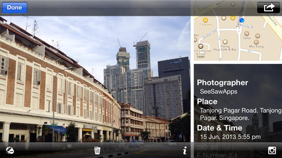
After this, users who want to share the addresses they found their awesome shots can do so in an even easier way. Pulling up the images in their gallery gives users the option, by clicking the leftmost button at the bottom of the screen, to pull their image into a frame, along with a map and some of the most pertinent metadata information. This allows users to share even more of their adventures with their friends. Is sharing an image, with a location, simply not enough? Add the location, F-Stop, shutter speed, address and date and time to your image, and your friends will never be able to ask you where you took a beautiful shot again, they’ll just know. This is also a great feature for people interested in getting feedback on their images, as they’ll now be able to get that advice based on the real settings used on the camera, instead of the sometimes faulty memory of the photographer.
Overall, the largest problem with Map Camera is that although the app tries to be ultra-simple and intuitive, it ended up looking like it had too few features. A look at the description for the app on the app store allowed me to find more features that I didn’t know the app possessed, such as the ability to change the location stamp font color, and the address displayed on the image. However, the app produces exactly what it says it does, a way to add maps to your images, as well as metadata, to help budding photographers share their skills and develop them, as well as adding maps to remember how to get back, and help direct fellow photographers, to great shooting spots. This app is well-worth the $0.99 asking price.

